


« March 2009 | Main | June 2009 »
May 29, 2009
An earthquake hits Roatan
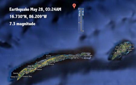
At 3:24 in the morning, a strong earthquake, measuring 7.3 on the Richter scale, hit Roatan. According to the USGS, the epicenter was at 16.730°N, 86.209°W, less than 20 miles north off the eastern tip of Roatan. The earthquake had a shallow depth of just 10 kilometer, with shallow earthquakes usually creating greater damage. This earthquake apparently happened as the result of movement on the Swan Islands fault, which is a segment of the boundary between the North America and Caribbean plates. The plates there move about an inch a year and cause frequent earthquakes. The last major one caused by friction between the North America and Caribbean plates happened in February of 1976 in Guatemala. That one measured 7.5 on the Richter scale and resulted in almost 25,000 deaths.
Despite the magnitude and proximity, this earthquake appears to have done far less damage. As of May 29, the USGS reported six fatalities, 40 injuries, and 130 buildings damaged or destroyed in northern Honduras, with the earthquake also felt in the entire region.
I read about the earthquake a few hours after it had occurred and worried about how it had affected Roatan itself. The Cocoview resort has a website with two webcams as well as a very active bulletin board. I was relieved when I saw both cameras online, showing no apparent damage to the dock area with the boats nor to the structures on the water in front of the resort.
Apparently, Cocoview had neither lost power nor internet access for any length of time as reports began coming in on the CoCo Chat bulletin board. "Doc" Radaswki reported that everyone on the staff and their families were okay, and that the resort itself was okay as well, except for broken water pipes and major clutter from things falling down. He reported that the home of Jorge, who had been our boat captain the first time we visited Roatan, was badly damaged.
There were also reports from underwater and those sound quite intense. It was reported that the wreck of the Prince Albert had a big buckle and crack in one area, and another new crack running all the way down the ship from top to where it rests in the sand. It was also reported that huge pieces of coral had broken off walls and toppled.
A second report by the same source (user name Habib at CoCo Chat) said that a large number of sponges had simply been sheared off at the base, that there was much damage to Neuman's Wall near the Prince Albert, with pieces broken off the wall and falling to the bottom, exposing edges of long dead coral. It was mentioned again that the Prince Albert had developed large holes, with rust clouds still spewing out. Habib also reported "weird noise we are all hearing underwater...like distant sonic booms reminding me of rolling thunder...you can feel the concusions in the water..."
The underwater reports sound drastic, above water it seems that the area got away with far less damage than could have happened with such a strong earthquake so close. The 6.7 quake that hit Los Angeles in 1994 caused $20 billion in damage.
Doc Radawski reported a couple of days later that two popular dive sites -- Mary's Place and Calvin's Crack -- appear to have survived intact, with sponges sheared off and some new cracks visible on top of the reef, but no visible structural damage or changes.
Dr. Rob Davis of the Whale Shark & Oceanic Research Center on Utila also checked the south east and south west dive sites and found only "minor damage here and there." He reported that the "Labyrinth had a new crack, but overall nothing too dramatic."
Two other divers reported that the damage they saw was depressing, but that for those who don't know every nook and cranny of the sites, there is still a lot of beautiful reef left. They, too, reported that the big barrel sponges do seem to have suffered the worst damage, and that a chunk of Newman's wall closest to the wreck of the Prince Albert came down. They had also gone to the Anka's Place dive site and when they went over the edge of the wall, there was just two hundred feet or so of gray concrete-looking rubble instead of the coral wall and overhang. They also visited Calvin's Crack, and found that other than a couple of big sponges that had come off, the site looked much the same.
Posted by conradb212 at 3:39 PM
May 20, 2009
Diving the Folsom Lake parking lot
For the first time in three years I got to dive again in Folsom Lake where I'd done my certification dives three years ago.
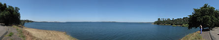
Folsom Lake is, strictly speaking, not a lake but a reservoir, with the water held back by Folsom Dam. The dam was built in the 1950s to provide flood control, electricity, and water for irrigation and drinking. When full, the lake covers an areas of about 18 square miles, not huge, but large enough to have marinas with many hundreds of boats. Folsom Lake, however, is rarely full. For one thing, its flood control duties mean that it must always hold some capacity in reserve. For another, it can get pretty dry in California, and so the amount of snow falling onto the Sierra Nevadas to the east of the lake will determine how full the lake will be in any given year.
The volume of reservoirs is commonly given in acre-feet, an acre being roughly 44,000 square feet (43,560, to be exact), an area just a bit smaller than a football field. An acre-foot is the volume that covers an acre with one foot of water, or 43,560 cubic feet. Folsom Lake's capacity is given as 975,000 acre-feet, which is about 318 billion gallons, or for those who think in terms of oil, about 7.5 billion barrels. As far as reservoirs go, Folsom Lake is not a giant one, being dwarfed by Shasta and Oroville that have capacities of 4.5 and 3.5 million acre-feet, respectively. Because of its relatively small size and reliance on snowfall in the Sierras, the waterlevel of Folsom Lake tends to go up and down dramatically. On May 20, 2009, with the lake almost full at 932,000 acre-feet, the water level elevation was 462 feet, but elevation can vary from a maximum of 480 feet to a minimum of about 350 feet, a difference of 130 feet.
I'd gone up to Folsom Lake during times of drought when the waterlevel had fallen to just 22% of capacity with large areas of formerly submerged land suddenly dry. The lake level had gone down so much by the end of 2008 that visitors were asked to stay away from what could be archaeologically valuable sites, such as the remnants of building foundations from farms and other structures that once stood where Folsom Lake is now.
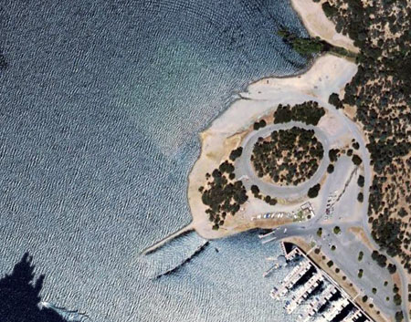
Since the Folsom Dam was designed not only for flood control but also as a recreation area, its designers made sure that the lake would still be accessible for boats when the water level was low. For that purpose they built a secondary parking lot and boat ramp at the far end of the Brown's Ravine marina area. That parking lot is underwater when the lake level is high. When we did the certification dives, instructor Chuck had casually mentioned "the parking lot" but I had thought it was some sort of natural underwater formation, not a real parking lot. But when we went in, we were actually diving and hovering over the parking lot.
Below is an aerial view of the submerged parking lot. You can clearly see the outlines of the lot underwater at 10 o'clock off the dry land. On our dive, the water level was quite a bit higher yet.
This time, the water level was higher yet, with the access road to the parking lot itself flooded halfway up. A lot of trees were almost entirely underwater, so water this high is apparently not something the trees expect. Our plan was to enter the lake at the access road to the parking lot, then follow the perimeter of the parking lot counter clockwise until we reached the boat ramp and then go down the boat ramp if conditions were conducive.
We had no idea what the water temperature was going to be, or what visibility to expect. A web search yielded widely varying temperatures. A triathlon event that included swimming in the lake suggested water temperatures in the high 60s towards the end of May. However, for environmental reasons (fisheries, etc.), the operators of Folsom Dam are trying to release water at a steady 57 degrees. As for visibility, I had thought it might be quite good. After all, 70% of all the water in Folsom Lake was brand-new water directly from the snow-packed Sierras. So I had visions of hovering over the parking lot and being able to see it from one end to the other.
Reality is always a bit different. We had suited up in 7mm wetsuits, gloves and hoods, and that turned out to be a good choice. The water temperature on the surface and down to about 15 feet was a balmy 71 degrees. Though the water was very clean, visibility was only fair, perhaps 10-20 feet. We followed the yellow double line in the center of the road, then the right edge of the road until we reached the parking lot. Between 15 and 20 feet was a fairly steep thermocline with the water temperature dropping from 71 to 57 degrees. It still didn't feel cold, though. 23 minutes into the dive we reached the top of the boat ramp which was now 25 feet underwater. We went down the ramp along its rightside edge. It was getting colder now and there was much less light. At 75 feet we still had not reached the bottom of the ramp, but decided to turn around as the water was now 49 degrees. Amazingly, it felt nowhere near as cold as in San Diego at the Yukon where 50 degrees had felt debilitatingly cold.
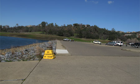
Below is a picture of the lot when it is not flooded. The yellow "No Parking" block marks the top of the boat ramp that was about 25 feet underwater on our dive.
Going back up the ramp took another ten minutes and then we followed the perimeter of the parking lot on the other side of the ramp. The whole time we'd seen plenty of fish, mostly bass, and numerous schools of tiny fish. The bass did not seem afraid in the least and easily came within reaching distance. We also found a pair of fully functional reading glasses and what looked like a small, cut diamond (it wasn't real). I am not sure how Carol managed to find it, but she did. A good hour into the dive we left the perimeter of the parking lot and promptly got lost on it. Since we'd been in just 15 feet of water for a while, a quick ascent to the surface showed which direction to go. At the end it had been a 70 minute dive, and a thoroughly enjoyable one.
What surprised me was just how much silt and sediment had formed on the road and on the parking lot in just a few weeks. It wasn't enough for a serious silt-out, but swimming close to the bottom whirled up quite a bit.
A lot of people sneer at Folsom Lake for diving, even those who got certified there. For the most part, they are right. There isn't much to see underwater and during certification it's mostly descending to 30 feet or so and demonstrating skills. But diving the parking lot and the ramp was a lot of fun. It just felt so weird to dive over where we had parked just a couple of months ago. And during the drought last Fall, we even had taken the car down the ramp and parked on the lake bottom, probably a good deal lower than the 75 feet we had reached on the ramp.
With the conditions we encountered, not only is Folsom Lake an enjoyable dive, but it'd also make a terrific place for underwater navigation on the parking lot, and for deep dive training by simply following the ramp down (it probably ends well below 100 feet when the lake is this high). And the price of admission is a grand total of eight dollars for a day pass to the area.
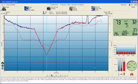
The image below shows the computer log of the dive. Going down and then back up the boat ramp made for one of the more interesting looking dive profiles.
Posted by conradb212 at 4:59 AM
May 2, 2009
Nasty letter from PADI
Today, much to my surprise, I received a nasty letter from PADI's legal department. It went:
"Dear Mr. Blickenstorfer:
I am with PADI's Legal Department. PADI is the distributor of DSAT’s Recreational Dive Planner. Please be aware that you do not have the rights nor permission to use DSAT's various dive tables on your site http://www.scubadiverinfo.com/2_divetables.html. To be able to use DSAT’s copyrighted materials, a license agreement would need to be in place. At this time, we have no interest in pursuing a license agreement.
We must request that you please take these portions of your site down immediately. Also, we would appreciate a written confirmation from you that you understand and will comply with this request. Thank you in advance for your anticipated prompt cooperation."
The missive was directed at my having a picture of the PADI dive table on our scubadiverinfo.com site. PADI dive tables are quite complex and convoluted, and so I took the time explaining them with examples. Everyone said that was a great idea. Everyone except PADI, that is. Don't these folks realize PADI, and diving, needs all the help it can get?
And not only are those puffy legal eagles threatening me, but then they condescendingly declare that "At this time, we have no interest in pursuing a license agreement."
Get real, guys!
Posted by conradb212 at 12:27 AM