
« November 2006 | Main | January 2007 »
December 26, 2006
What Santa brought
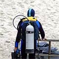
Well, Santa apparently knows that I am an avid diver and reader.
I am forever searching for new diving and scuba related books. So I received "Basic Decompression - Theory and Applications" by Bruce R. Wienke, "Submerged - Adventures of America's Most Elite Underwater Archeology Team" by Daniel Lenihan, "Hiding on the Bottom - Mid Life Misadventures Down East" by James Rosemond, and "Mastering Rebreathers" by Jeffrey E. Bozanic. I also got the entire United States Navy Diving Manual on a simple unadorned CD.
And I got a very cool black Scubapro sweatshirt. It'll come in handy on my morning runs until, hopefully soon, I can wear it after dives. I also received a handy angler/diver combination tool with more functions than a Swiss army knife (I know, I was born there). And yet more diving gear: a compact and incredibly high tech-looking LED dive light. I cannot wait to go on another night dive! And I didn't know Monopoly sets came in an Underwater World Edition. Yeah! To remind me of the gator that swam above us in the Manatee Springs State Park Catfish sink, I got an alligator Christmas ornament. It arrived, well protected, in a small gear bag.
I also received another, early, Christmas present in the form of a very complimentary email from the author of one of my favorite diving books. Yes, Shadow Diver author Robert Kurson sent me the following on December 16:
Dear Mr. Blickenstorfer,
I can't thank you enough, not just for the kind words, but for the
extraordinary review you wrote. It's one of the sharpest reviews I've ever
received, and it's very nicely written, to boot! I'm truly honored, sir, and
I'm taking the liberty of passing along the review to John Chatterton and
Richie Kohler. I just spoke to John this morning and know he'd love to read
it (if he hasn't already).
In the meantime, please forgive the lateness of my reply - I just completed
work on a new manuscript and had lost myself in it for some weeks.
I hope you're having a very happy holiday season. And thanks again for
connecting to exactly what I believed was most important in the Shadow
Divers story.
Best,
Rob
Posted by conradb212 at 11:03 PM
December 25, 2006
Mapping diving sites
It's the end of the year, and while that doesn't represent an unbearable climactic hardship in generally sunny California, all my Scuba gear is safely stored away and I don't know when I'll be able to don and use it next. In the summertime at least I could simply hop in the pool and peruse the world from 8 feet under. Not very exciting, admittedly, but it did mean putting my gear on and breathing underwater.
Fortunately, there is a way to go and see places during off-season, ever far away ones. How? By using Google Earth, that miraculous satellite mapping program Google bought a couple of years ago. I had used it when it first appeared and immediately fell in love with it. When you crank it up you see the planet earth from space. Type in an address or landmark, and the program takes you on a ride there, as if you sat in some future spacecraft. The earth comes closer, then you see the continents, individual mountain ranges and seas and lakes, and then you zoom into your location, until you're, well, there. Yes, you can see individual homes and even cars. You can see your driveway and swimming pool if you have one. And, through the miracle of satellite photography, you can do that for just about every place on earth.
From there it's a small step to investigating all those diving places you've heard of and plan on going to: Bonaire, Palau, the Caymans, Socorro, Cozumel and what have you. Shamefully, I must admit that while the mere mention of those places by my diver friends raises anticipation and longing in me, my geography has become a bit rusty and I didn't know where some of them were.
Well, with Google Earth, a free application you can download from earth.google.com, you can spend hours and days flying from location to location and actually see the places. Even geographic expert will at times be surprised when a dive location isn't where they thought it'd be. Or what it looks like from way up high.
While Google Earth is great, I took it one step farther and programmed a mapping system right into the "Places" section of this website. Yes, you can do that by using Google's technology and boning up a bit on their mapping APIs (application program interfaces). It began when Carol and I talked about how cool it'd be to be able to click on one of the almost one hundred dive sites she's listed. That would bring up a marker on the world map and you could then zoom in until you were right there!
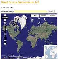 A few hours of programming did the trick. We had a zoomable world map. Now it was just a matter of entering the data for all those dive locations. That turned out to be trickier than we thought. Sure, you can look up an address and enter that, but the Google database at times substitutes the address for one closeby. Or there is no precise address, and so the marker sits in some unlikely place when you zoom in. Eventually we began using Google Earth to precisely locate places, then copy their latitude and longitude and use those coordinates in our own mapping system. As a result, some locations now have markers literally within feet of the actual location of a divesite. Others are a bit more approximate and pinpoint the general vicinity. And sometimes it took a good bunch of research and googling to track down coordinates.
 The result is just too cool. The picture above shows the world map you first see. To the left are the zoom and pan controls, and you can also just drag the map around. You can also switch between a satellite picture (as shown) or a map, or even a hybrid.
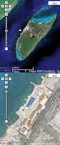
There is nothing like actually "flying" to, say, Cozumel, see the island off the coast of Mexico, its shape, its vegetation and terrain, and then see where an actual dive site is. The picture on the right shows an overview and then a closeup of the west coast with the hotels and piers. I should mention that the quality of the photography is not always the same. Metropolitan and other important areas usually have high quality, high resolution photography. Places off the beaten path are much lower resolution or they may not be as carefully patched together. Sometimes pictures used have clouds on them and, perhaps the biggest drawback, the photography can be several years old. I don't know whether that is due to cost considerations or perhaps for national security reason.
I have no idea how many people will discover the work we did and use our dive site mapping system. During research I found other efforts out there, and one, in partcular, was impressive. It even let people add their own dive sites, and you could select sites by country, depth, difficulty, and several other critera. Such discoveries can be discouraging, but our work is pretty good also, and Carol has personally been to each and every one of the locations.
The only problem is that now I have an even greater desire to pack up my gear RIGHT now and go to some of those places!
Posted by conradb212 at 11:02 PM